We need to better prepare our communities for the effects of ongoing changes to weather patterns and rising sea levels.
The impacts of climate change affect us all, and in Tasman we continue to experience the effects of significant weather and storm events. By coming together to look at what we know about sea level rise and coastal hazards in Tasman, and the options we have for responding, we’ll be better prepared for making decisions in the future.
We have started the conversation with our communities to talk about how we can respond to sea level rise and coastal hazards by identifying high-level options that enable us to adapt. The options are grouped into four categories – accommodate, protect, avoid, and retreat.
At this stage, our focus is to raise awareness and develop a common understanding about what we know and the options we have. These are complex issues, so it is important we start the conversations now because the decisions we make over the coming years will affect generations to come.
Between 6 September and 15 October 2021 we undertook community engagement on the four high-level options for coastal management to understand your views on these options and if there are alternative options or ideas for coastal management that we should consider. This will ensure that we avoid narrowing down the options too early in the process.
Thank you to all those who shared their feedback which has been summarised into the following report: Coastal Management Options – Summary of Community Feedback (March 2022) (pdf 757 KB)
This work will stand us in good stead for future conversations and it will influence Council’s work programmes, including the process to create our new resource management plan, Aorere ki uta, Aorere ki tai – Tasman Environment Plan.
Key work and resources:
This work is guided by recommended good practice set out in the Ministry for the Environment’s Coastal Hazards and Climate Change Guidance (2017).
In late September 2021, we held three community online events. The webinars were an opportunity to find out more the Tasman District Council Coastal Management Project, what’s at risk from sea level rise and coastal hazards, and our options for responding.
This is a recording of a webinar held on 28 September 2021 with presenters Dr Rob Bell, Diana Worthy, Glenn Stevens, and facilitated by Nicole Taber.
The webinars followed community sessions held in 2019, during the early stages of the project. The conversations in 2019 helped to gather feedback on what people value that may be affected by sea level rise and coastal hazards. That feedback helped inform our report assessing coastal risk and vulnerability (during 2020).
The conversations we are having now are at a broadly regional level, to understand the range of possible coastal management options. Next steps in the Coastal Management Project will be to consider specific options at the local level around Tasman. This will include considering their respective costs, benefits, and potential adverse effects - and which are acceptable or not.
Long-term adaptive planning work will take several years to complete and the community conversation will be ongoing.
We’re working on a project aiming to enable our Tasman Bay / Te Tai o Aorere and Golden Bay/Mohua communities to work towards long-term adaptive planning for sea level rise and coastal hazards.
While the rate and magnitude of future sea level rise is uncertain, we do know that rising sea levels will have increasing implications for development and infrastructure in coastal areas along with environmental, cultural and societal effects.
We’ve prepared a map showing various scenarios, click on the link below to view.
Coastal hazards map viewer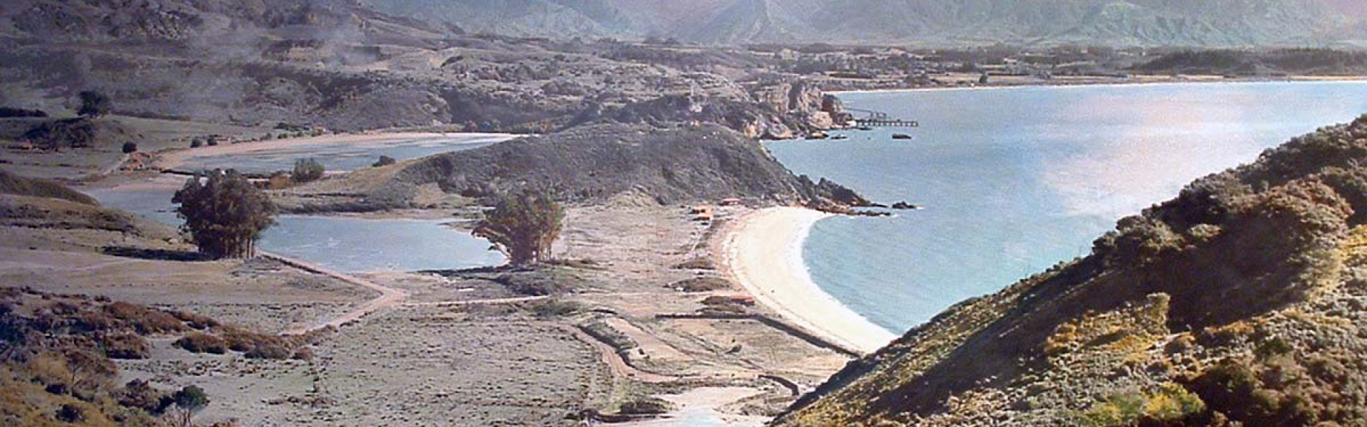
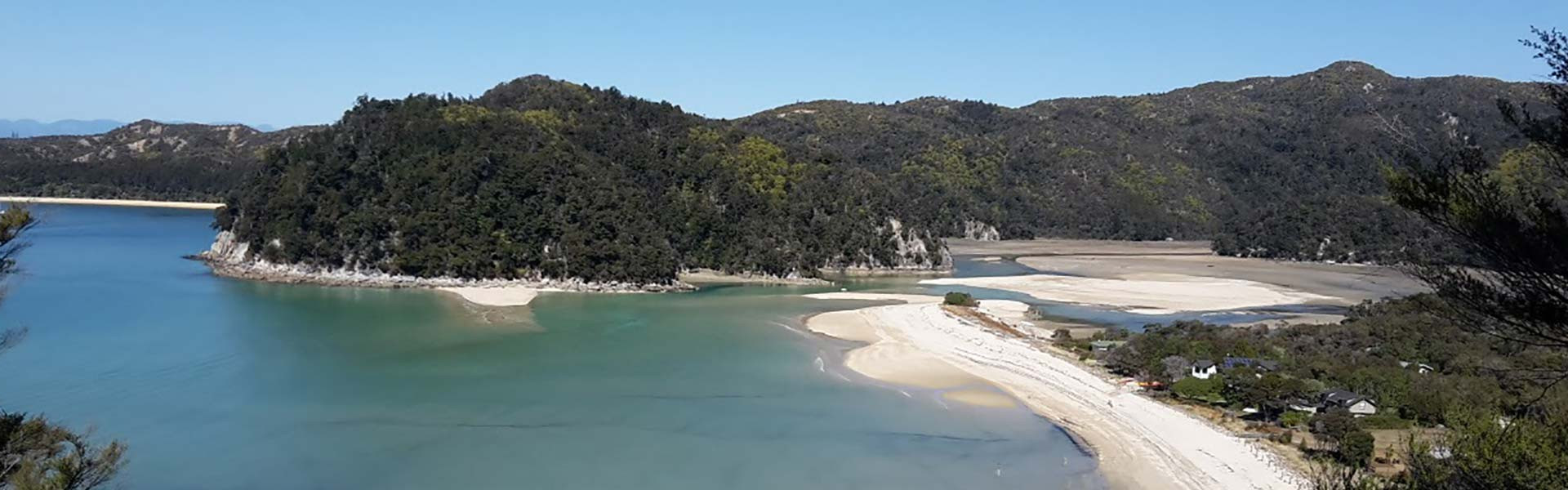
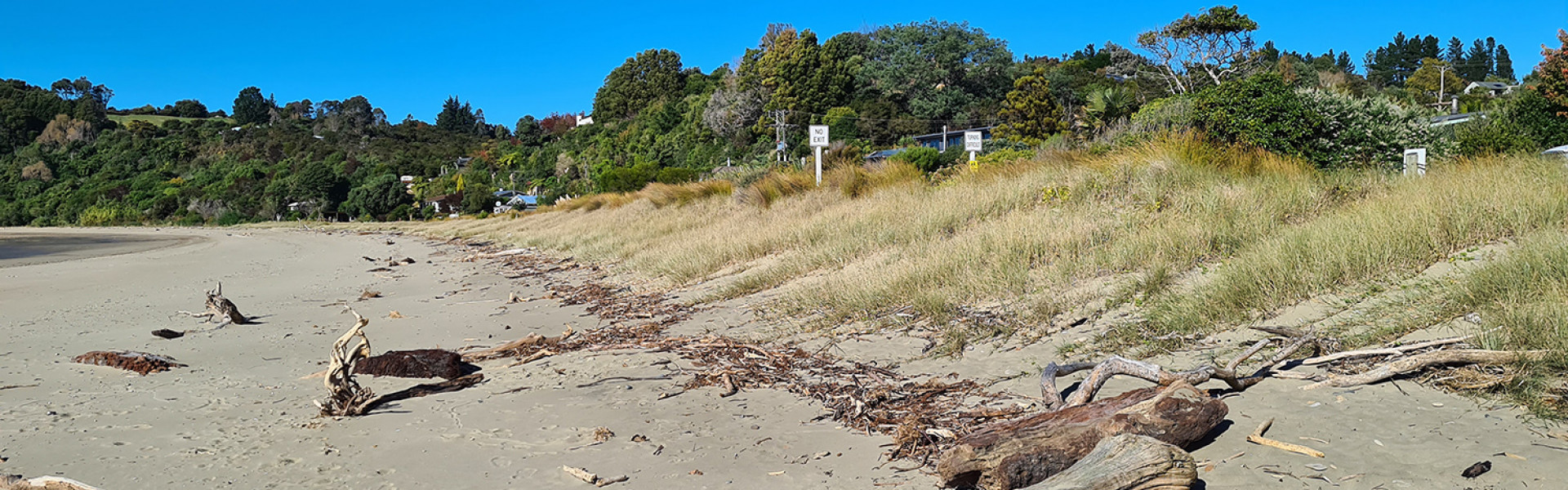
Tasman's coastline spans over 700km of open coast and estuary shorelines, the geography ranges from rocky and cliff landforms to dunes, sandy beaches and sand spits.
Treasured by our communities and visitors alike, it stretches from the rugged northwest coast, the uniqueness of Farewell Spit, the seaside communities in Golden Bay/Mohua, the golden sands of Abel Tasman National Park, and the expanse of the Waimea Inlet.
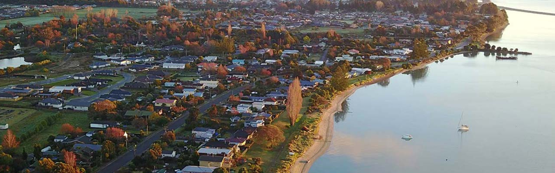
Over time our communities across Tasman Bay / Te Tai o Aorere and Golden Bay / Mohua have become synonymous with summer sun, sea and camping. As well as permanent residents, these areas attract holiday makers from across New Zealand and internationally.
Our coastal communities have diferent characteristics. Some are linear development (e.g. Pākawau, Ruby Bay), some are on sandspits and small peninsulas (e.g. Totara Avenue, Parapara, Tata Beach, Torrent Bay, Kina), while others are in bays (e.g. Ligar Bay, Kaiteriteri), or are larger townships on river/coastal plains (e.g. Collingwood, Motueka, Richmond).
Our coastal environment holds significant environmental and cultural values, provides employment and economic opportunities, numerous recreational activities and experiences, as well as being a great place to live.
Like other coastal communities around New Zealand, Tasman has experienced and will continue to experience the impacts of coastal hazards. Many parts of our coastline are vulnerable to coastal storm inundation and/or coastal erosion. Ex-tropical cyclones Drena (1997) and Fehi (2018) are two notable examples of storm surge events which caused significant damage along our coastline.
The probability, severity and extent of coastal inundation and erosion hazards will increase as a result of projected climate change and associated sea level rise and increased storminess.
“Legends tell of Uruao, the first of the Polynesian voyaging canoes to land ... like the rest of New Zealand, Nelson was first settled around the ninth century.
Gardens were quickly established throughout the region, including alongside the Waimea River, and in Motueka and Riwaka, Mapua and Parapara.
Most villages were on the coast, close to river valleys. The location of each settlement was planned with both transport and food in mind. Waka (canoes) were used around the coast and up river valleys.”
From Jim McAloon’s “Nelson: A Regional History” (1997)
Human activities such as driving, flying in planes, making things in factories, farming and so on release greenhouse gases in the atmosphere. These gases trap heat and are causing the world’s climate to change.
Climate change will affect different parts of the world in different ways. It is likely global temperatures and sea levels will rise, and weather such as rain, snow and wind will become more intense.
These changes will affect our lives, our health, economies, natural ecosystems and more.
New Zealand, and Tasman, needs to be prepared for a future of changing climate. As well as mitigating the problems, we need to work together to ensure that we, as a community, are prepared and ready to adapt to our ever changing environment and natural hazards.
Read more about how climate change is affecting our district and Council’s Climate Action Plan.
From the Ministry for the Environment website:
Climate change is the biggest environmental challenge of our time. It is already affecting our climate, agriculture, native ecosystems, infrastructure, health and biosecurity. If left unchecked it will have broad social and economic impacts.
Read more about climate change on the Ministry for the Environment website
We cannot afford to ignore what is happening in New Zealand and globally.
Source: Ministry for the Environment website
Historic sea level rise in New Zealand has averaged 1.78mm per year, with the Port Nelson tide gauge recording a slightly lower rate than the national relative average of 1.57mm per year (MfE, 2017).
Sea levels measured at Port Nelson in 2017 (averaged over the period 2008 to 2017) are now 150mm higher than sea levels measured 75 years earlier in 1942 (averaged over the period 1939 to 1942) (NIWA, 2018). Much of the observed sea level rise has occurred in the latter part of this period.
The rate and magnitude of future sea level rise is uncertain, especially later this century and beyond. Scientists advise that sea levels will continue to rise and that levels are likely to rise at an accelerated rate over time as the earth’s temperature rises, meaning changes could happen sooner than predicted – or there may be changes to emission rates that reduce the rate of warming. Uncertainty is a key message. What we do know is that rising sea levels will have increasing implications for development and infrastructure in coastal areas along with environmental, cultural and societal effects.
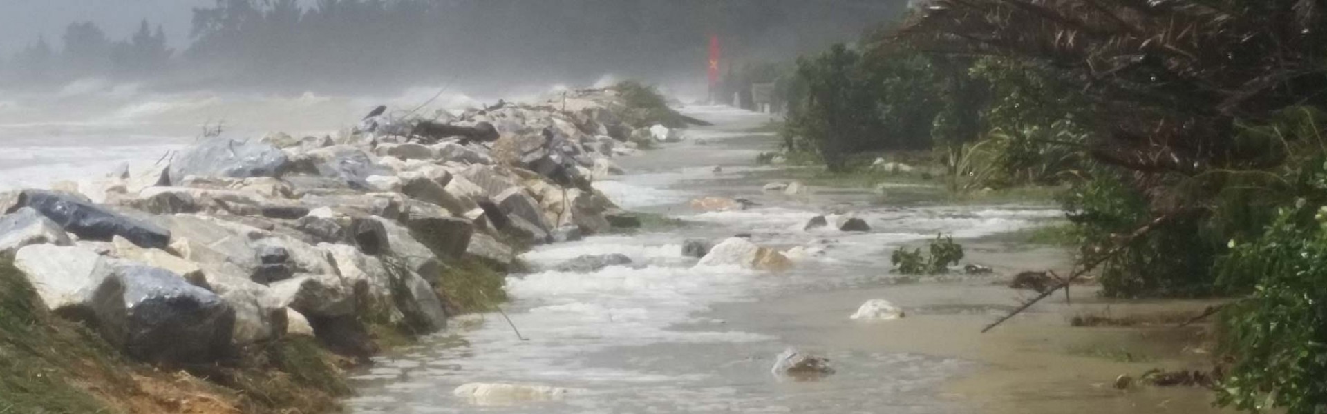
Ex-tropical cyclone Fehi was a significant coastal storm inundation event that effected our district on 1 February 2018. The large storm surge which coincided with a high spring tide and large waves damaged the coastline and flooded roads, reserves and nearby properties and houses. Sea level rise will increase the exposure of our coastal land to these type of events, creating new hazards in areas that have not previously been exposed.
Our sandy beaches and shorelines are subject to natural processes of coastal erosion (sediment loss) and coastal accretion (sediment gain). Beaches or shorelines will often experience a cycle of erosion followed by accretion, with the duration of the erosion-accretion phase ranging from weeks (the period of a storm event and post-storm recovery) to longer periods over a year(s), a decade or several decades.
In some areas of the district, coastal erosion is already affecting roads, reserves and private property. Mitigation measures (such as walls, rock revetments, sand push-ups) are already undertaken on parts of the district’s coastline. Sea level rise will increase the exposure of our coastal margins to coastal erosion and accretion, creating new erosion hazards in areas that have not previously been exposed.
The Ministry for the Environment has developed a series of factsheets which provide further information on the different elements of coastal processes. View the factsheets on the Ministry for the Environment website.
Through Council’s activity management plans we already identify Council infrastructure and assets that are vulnerable to the impacts of climate change.
View our Activity Management Plans
Nationally, climate change and any adaptation response will present new challenges (as well as new opportunities) for iwi, hapū, whānau and Māori enterprise.
Eight iwi are tāngata whenua in Te Tau Ihu (the top of the South Island). Tasman District also covers the northern part of the Ngāi Tahu takiwā (tribal area/territory). These iwi have all been through Treaty of Waitangi settlement processes and the resulting statutory acknowledgement documents contain information on the cultural, spiritual, historic and traditional associations each of the iwi have with the coastal areas in Tasman District.
VIew Te Tau Ihu Statutory Acknowledgements
Some iwi authorities have also lodged iwi management plans with the Council. These plans are a written statement identifying important issues regarding the use of natural and physical resources for the iwi and are lodged with councils under the Resource Management Act 1991.
These information sources provide a starting point for our discussions with iwi on responding to climate change.
There is a growing body of national research which considers the effects of climate change (including sea level rise) and natural hazards, and how we can respond, adapt and thrive.
Read about our Coastal Risk Assessment and other agencies national risk assessment work.
The Government’s 11 ‘National Science Challenges’ research programmes bring together the country’s top scientists to work collaboratively to tackle the biggest science-based issues and opportunities facing New Zealand. Two Challenges relevant to our work are:
Research: Insurance Retreat in Aotearoa New Zealand
This Deep South National Science Challenge report analyses the change in frequency of coastal flood events over the next few decades and how quickly sea level rise induced ‘insurance retreat’ will affect coastal areas in Auckland, Wellington, Christchurch and Dunedin. Also, it estimates how expected sea level rise translates into higher insurance premiums.
Using the principles of the Ministry for the Environment’s Coastal Hazards and Climate Change Guidance (2017), our work programme will span a number of years as we engage with our Tasman Bay and Golden Bay communities to:
by developing an understanding of sea level rise and coastal hazards in our district.
by identifying areas, objects or experiences that we value that may be impacted and assess their risk and vulnerability.
by identifying and evaluating options to enable adaptation.
Coastal Management Options – Summary of Community Feedback (March 2022) (pdf 757 KB)
which will be implemented through a number of work programmes such as the Tasman Resource Management Plan, infrastructure and reserves asset management planning, and to help inform emergency management.
by monitoring and regular review of the strategy.
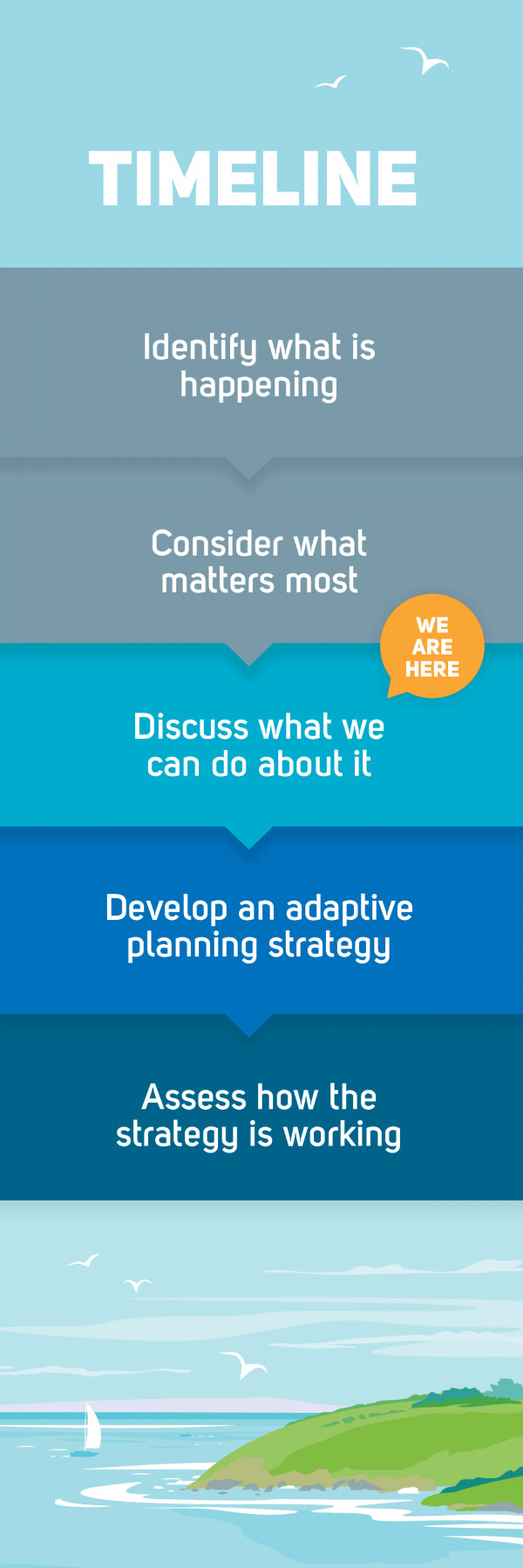
This is a long-term process to agree how our community deals with climate change and coastal management issues. We are at the second stage of this process.
Our mapped sea level rise elevations information is based on the Ministry for the Environment’s Coastal Hazards and Climate Change Guidance (2017).
The Guidance outlines the approximate years, from possible earliest to latest, when specific sea level rise increments (in metres above 1986-2005 baseline) could be reached for various projection scenarios of sea level rise for the wider New Zealand region, as shown in the table below.
The representative concentration pathways (RCPs) listed are four comparable scenarios used to predict how future global warming may contribute to climate change and sea level rise. The lower scenario (RCP2.6) represents the rise in sea level if the Paris Agreement was achieved, namely to keep the global average temperature well below 2° C above pre-industrial levels, while pursuing efforts to limit the temperature increase to 1.5° C. The upper scenario (RCP8.5 H+) represents continuing high emissions and no effective emissions mitigation, plus runaway instabilities in polar ice sheet melting. The other two scenarios (RCP8.5 and RCP4.5) are in between those two different futures.
For example, based on current information we may expect 1m sea level rise by the years 2100 (RCP8.5+), 2115 (RCP8.5), 2170 (RCP4.5) or beyond 2200 (RCP2.6).
| SLR (metres) | Year achieved for RCP8.5 H+ (83%ile) | Year achieved for RCP8.5 (median) | Year achieved for RCP4.5 (median) | Year achieved for RCP2.6 (median) |
|---|---|---|---|---|
|
0.5 |
2060 |
2075 |
2090 |
2110 |
|
1.0 |
2100 |
2115 |
2170 |
>2200 |
|
1.5 |
2130 |
2160 |
>2200 |
>2200 |
|
2.0* |
>2150* |
>2195* |
>2200* |
>2200* |
*extrapolated out based on MfE’s 1.9m sea level rise scenario.
Given that the rate and magnitude of future sea level rise is uncertain, all four RCP scenarios should be considered when developing our long-term adaptive planning approach.
Each increment of sea level rise will depend on the rate of future global warming and climate change.
Scientists advise that sea levels will continue to rise and that levels are likely to rise at an accelerated rate over time, meaning changes could happen sooner than predicted. We don’t know exactly when each increment will occur, but our mapping helps to identify where sea level rise may impact low lying land.
While there is much uncertainty around the rate and magnitude of sea level rise, we do know that rising sea levels will have increasing implications for development and infrastructure in coastal areas along with environmental, cultural and societal effects. Therefore, regardless of this uncertainty we need to be proactive in our long-term adaptive planning for sea level rise to ensure our communities are resilient. The decisions we make today will affect our children, grandchildren and future communities.
Broadly speaking, the warmer the climate becomes, the faster sea levels will rise.
Coastal Management Options