Acronyms and web links | About the WCO | Water Quality | Triggers | Future Plans
This page has been established to share the journey for implementing the Water Conservation Order (WCO). The Order issued in 2023 protects the vital Te Waikoropupū Springs and Wharepapa Arthur Marble Aquifer (WAMA).
The Te Puna Waiora o Te Waikoropupū Springs and Wharepapa Arthur Marble Aquifer WCO 2023 recognizes the crucial link between the aquifer and the springs and aims to protect both. The travel time of water through the aquifer to the springs is estimated to be around 8 years, highlighting the long-term impact of activities on the aquifer's health.
WAMA serves as Te Waikoropupū Springs' lifeblood, offering exceptional clarity and consistent flow. Its centuries-long marble filtration yields renowned clarity, while acting as a natural reservoir sustaining spring health.
Underlying Tākaka Valley, the WAMA is a large and complex karst aquifer system, estimated to be around three cubic kilometres in size. Approximately two thirds of the flow in the aquifer flows out at Te Waikoropupū Springs. The Springs holds deep cultural significance for local iwi and community, and it is intricately woven into manawhenua cultural identity and traditions.
Council is committed to implementing the WCO and recognises the importance of Te Waikoropupū as a taonga for the region and will be seeking best water and land use practice in the catchment in collaboration with iwi, landowners, and the community.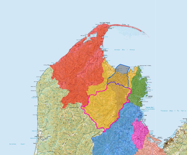
What to expect from this page
You will have insight into
Questions and feedback
If you have questions or feedback about the content on this page, email us at wco@tasman.govt.nz.
Water Conservation Orders (WCO) provide one of the highest levels of protection to special waterbodies in NZ, aiming to protect their outstanding values and characteristics. They do this by influencing regional council functions for managing water quantity and discharges of contaminants.
Te Puna Waiora o Te Waikoropupū Springs and Wharepapa Arthur Marble Aquifer Water Conservation Order (TWS-WCO) came into effect on 19 October 2023 (available online here). It is the third WCO in Tasman – with others on the Buller and Motueka Rivers.
The TWS-WCO applies to the recharge area for the Wharepapa Arthur Marble Aquifer (WAMA). An estimated two thirds of flow in the WAMA flows out from Te Waikoropupū Springs. The WAMA recharge area (or WAMARA) is the area of catchment where land and water use has the potential to influence the quantity and quality of water flowing into the groundwater that feeds the Springs.
A map of this area is available here.
The WCO will be largely implemented through the Tasman Resource Management Plan (TRMP) and a plan change process is underway (more information on this process is available here).
The WCO potentially affects everyone living and working in the WAMARA who uses water, or creates discharges that could affect nitrate, phosphorus, dissolved oxygen, or clarity in the aquifer or at the Springs.
While WCO cannot affect existing water and discharge permit holders for the duration of their current consents, it will influence any replacement consents over time.
In addition, while some activities may be exempt from the WCO, the changes to the TRMP may also affect their activities over time as the plan seeks to implement the National Policy Statement for Freshwater Management (NPS-FM) and replacement legislation.
The WCO sets restrictions on council’s functions regarding management of water quality and flows at the springs. Specifically, the TWS-WCO:
The WCO also outlines duties for the Council, including offering a partnership with local iwi in protecting the Springs. These duties also include:
The WCO also provides for manawhenua iwi (Ngāti Tama ki Te Tauihu, Te Ātiawa, and Ngāti Rarua) to prepare a cultural health monitoring report to inform preparation of changes to the TRPS and TRMP and assessments of water and discharge permits in the WAMARA.
Water Allocation Limit: The allocation limit for the WAMARA is 766 litres per second.
Minimum Flow: The minimum flow specified in the WCO to protect at the Main Spring is 6895 litres per second.
Nitrate: The nitrate limit for the Springs is 0.41 milligrams per litre (to be reached by 2038).
Dissolved Reactive Phosphorus: The Dissolved Reactive Phosphorus (DRP) limit for the Springs is 0.005 milligrams per litre.
Dissolved Oxygen: The limit at the Main Spring for Dissolved Oxygen is a fifth percentile of at least 45% saturation.
Water Clarity: The limit at the Main Spring for Water Clarity is a median of at least 72 metres or a fifth percentile of at least 68 metres.
The WCO requires monthly sampling at two sites – the Main Springs and Fish Creek Springs (WCO site). The Council has undertaken 3-monthly sampling from the Main Spring since 1990 and various other sites e.g. Fish Creek Springs. Council has for some years also been monitoring a site in upper Fish Creek Springs – called Fish Creek Spring (TDC site). For continuity, and to meet the WCO Council has been monitoring all three sites monthly since June 2023.
All nitrate and dissolved reactive phosphorus data from the water testing at the sites required are available online here.
Water clarity and dissolved oxygen were measured continuously for three months in 2018 using specialist equipment given the very high-water clarity. A repeat of this measure is programmed for the 2024-25 summer in accordance with the WCO.
Council has also been monitoring the flows at the Main Spring since early 2000’s – this flow data is available in real time online here. While the WCO sets a minimum flow, the Springs can naturally go below this flow during times of prolonged dry weather. It is also a natural feature of the aquifer that when the Takaka Catchment gets dry and the Main Spring flow gets low, both the TDC and WCO Fish Creek Springs sites can go dry.
The water of Te Waikoropupū Springs is so clear it is a vivid blue colour, adding an extra vibrancy to the plants growing there. In 2018 NIWA produced this video following a three-month monitoring project measuring the clarity of the water for Tasman District Council. “Maintaining the existing clarity of Te Waikoropupū is a key priority identified through Council collaborative planning process with the Tākaka community under the National Policy Statement for Freshwater Management.” Read more here on the NIWA website.
Council has completed land use mapping, and this data is being used to identify land user types and models of their Nitrogen footprint. A biophysical risk layer is in the works to provide land users with a view of their vulnerabilities to Nitrate leaching and the type of tools that will be effective in reducing Nitrate.
Council is working with Farmers of the Arthur Marble Aquifer (FAMA) to develop implementation actions and solutions. This work will feed into the Freshwater Farm Plan Program (FWFP) to be rolled out in 2025. The Farm Plans will serve as a key tool in prioritising the actions to reduce nitrate leaching in the Waikoropupū Arthur Marble Aquifer Recharge Area (WAMARA).
The Tasman Regional Policy Statement (TRPS) and Tasman Resource Management Plan (TRMP) are an important way to help implement the outcomes sought in the WCO.
Provisions and rules in the TRMP can help provide an integrated regulatory response to ensure water and discharge permits, as well as land use and land use practices, in the recharge area are managed to protect the outstanding values and characteristics of the Springs and aquifer - and to assist in reaching the nitrate limit by 2038.
The WCO requires that Council use its ‘best endeavours’ to notify a plan change for land and freshwater management by 31 December 2024. At the time the WCO was made, this aligned with the RMA deadline for plan changes to implement the National Policy Statement for Freshwater Management 2020 (NPS-FM). The Government has since extended the NPS-FM deadline to 31 December 2027 given its intention to replace the NPS-FM.
Despite the NPS-FM deadline extension, the WCO requirement remains, and Council is endeavouring to progress the Land and Freshwater Plan Change (LFPC) to introduce both new provisions for the Takaka catchments and a supporting regional freshwater framework that protects the life supporting capacity of all waterbodies in Tasman. Further information on the Land and Freshwater Plan Change process is available here.
The plan change process will need to consider any Central Government changes made over the next few years to freshwater related legislation, including changes to the NPS-FM proposed in 2026.
For the Takaka catchments, the plan change will incorporate both the requirements of the WCO and the previous recommendations of
the Takaka Land and Freshwater Advisory Group (Takaka FLAG) (further information on the FLAG process and their report is available here.
NIWA post May 2018 Underwater footage shows exceptional clarity of Te Waikoropupū Springs