The ‘avoid’ grouping mainly uses land-use planning measures to stop putting people and assets in harm’s way. It seeks to avoid further intensification of existing built areas or the development of new sites in low lying coastal locations – this can be thought of as a “let’s not make the situation worse” approach. Land-use planning measures include policies and rules within resource management plans that control the types and densities of land uses (via zoning), subdivision and building restrictions, and coastal setbacks.
In terms of coastal management options, the best way to minimise and reduce coastal hazard risk is to avoid areas that are, or will become, exposed to coastal hazards. In doing so, this will avoid costly and avoidable risk which the Council and community would otherwise have to address in the future. The use of avoidance measures gives effect to the New Zealand Coastal Policy Statement 2010(external link) (Objective 5 and its supporting policies) which promotes locating new development away from hazard prone areas.
Download the (pdf 61 KB)Avoid option summary poster.
 The Future Development Strategy (FDS) sets out how the urban settlements and townships in the Nelson and Tasman regions will change and develop over the next 30 years. The FDS shows where future housing and business development is likely to be located, and how this development is likely to be phased and timed over the 30 year period.
In preparing the FDS, each potential growth site was assessed against 28 criteria to assess its suitability for housing or business use. Within our District, the Council avoided low-lying coastal areas subject to long term sea level rise by excluding all land below 5m NZVD2016 datum.
The FDS will inform a range of local plans and strategies, including the Councils’ Long Term Plans, Infrastructure Strategies, Regional Land Transport Plans, and resource management plans.
View the Nelson Tasman Future Development Strategy.
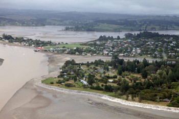 Coastal hazards are well documented in Māpua – Ruby Bay, including the effects of ex-tropical cyclones Drena (1997), Yali (1998) and Fehi (2018).
In the late 2000s, the Council initiated Tasman Resource Management Plan (TRMP) Plan Change 22 working with the community to address future development options, recognising coastal processes and the hazards they pose. The plan change was made operative in 2015 and directs future expansion of Māpua and Ruby Bay away from low-lying land and the inundation and erosion prone coastline, on to more elevated land northwest of the township.
The TRMP identifies a ‘Coastal Risk Area’ that provides a number settlement specific policies and rules that minimise the assets in the areas at risk, including prohibiting further subdivision and the construction of new habitable buildings in this area.
The plan change is the start of building longer-term community resilience for the Māpua/Ruby Bay community. The plan change is promoted by the Ministry for the Environment as an example of current good practice for coastal hazards planning.