We’ve prepared a coastal risk assessment to understand the vulnerability of Tasman Bay/Te Tai o Aorere and Golden Bay/Mohua to coastal storm inundation and sea level rise. The risk assessment helps us to consider what matters most, following the principles of the Ministry for the Environment’s Coastal Hazards and Climate Change Guidance (2017)(external link).
The assessment identifies assets, property, infrastructure, and facilities (known as ‘elements at risk’) that may be vulnerable, using readily available datasets.
Coastal Risk Assessment (2020 (pdf 2 MB)
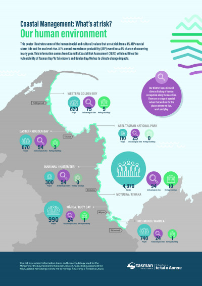
We have also prepared poster summaries of the risk assessment. Click on each image to view a larger version.
 [PDF, 207 KB] [PDF, 207 KB]
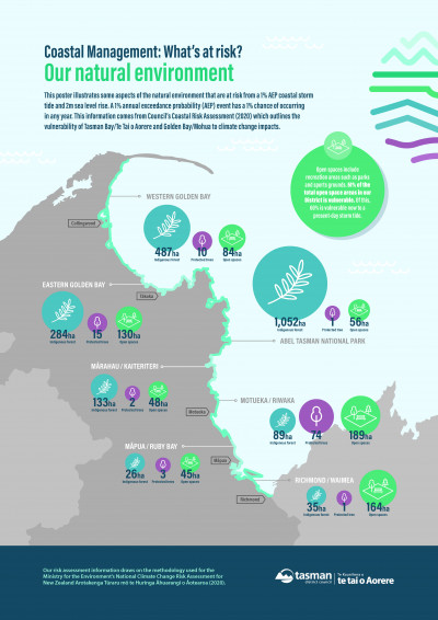
Natural Environment |
|
 [PDF, 181 KB] [PDF, 181 KB]
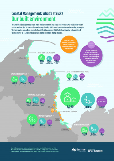
Built Environment |
 [PDF, 234 KB] [PDF, 234 KB]
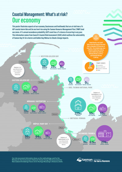
Economy |
Our work to date including this risk assessment will be used to inform our future work programme.
Several other agencies have also quantified New Zealand-wide risks and vulnerabilities to climate change and sea level rise and their reports include Tasman-specific data.
These reports are complementary to the information contained within our risk assessment and overall help to provide a broad understanding of the Tasman District’s vulnerability to coastal storm inundation and sea level rise.
The Parliamentary Commissioner for the Environment’s 2015 report identifies that in Motueka approximately 1,043 homes, 117 businesses, and 41km or roads lie less than 1.5m above the spring high tide mark (MHWS level).
Preparing New Zealand for rising seas: Certainty and Uncertainty (2015)
Local Government New Zealand’s 2019 report quantifies and values local government infrastructure exposed to sea level rise (increments of 0.5, 1.0, 1.5 and 3.0 metres).
The report identifies Tasman roading, ‘3 waters’ infrastructure (water, wastewater and stormwater), green spaces, and other facilities which are vulnerable to rising sea levels.
Vulnerable: the quantum of local government infrastructure exposed to sea level rise (2019)
Department of Conservation’s 2019 report identifies the Abel Tasman Coast Track as one of seven ‘icon destinations’ which have 10 or more vulnerable assets and/or more than 5% of vulnerable track.
Risk exposure of Department of Conservation (DOC) coastal locations to flooding from the sea (2019)
The National Climate Change Risk Assessment for New Zealand Arotakenga Tūraru mō te Huringa Āhuarangi o Āotearoa (NCCRA) was published by the Ministry for the Environment in 2020.
It provides a national overview of how New Zealand may be affected by climate change-related hazards, and identifies the most significant risks and opportunities. Tasman’s coastal risk assessment report draws on the same methodology framework as the NCCRA.
Last modified: